We’ve compiled a handy list of routes throughout West Cork that are ideal for both walkers and runners. None are too difficult and all take in elements of the beauty, history and heritage of the area while getting you out in the fresh air for some exercise – good for body and soul. So, the next time you want to go for a stroll or jog, take your pick – or why not set a goal for 2024 and do them all?
Mid Island Loop, Bere Island
ADVERTISEMENT
ROUTE
This route is a Sli na Slainte walk which was developed by the Irish Heart Foundation to make walking more accessible to the general public. It heads downhill to St Michael’s Church and Graveyard, along the low road, turning right at the crossroads and returns along the high road.
START/FINISH POINT:
Outside the Bere Island Hotel (Eircode: P75 RX59)
DESCRIPTION:
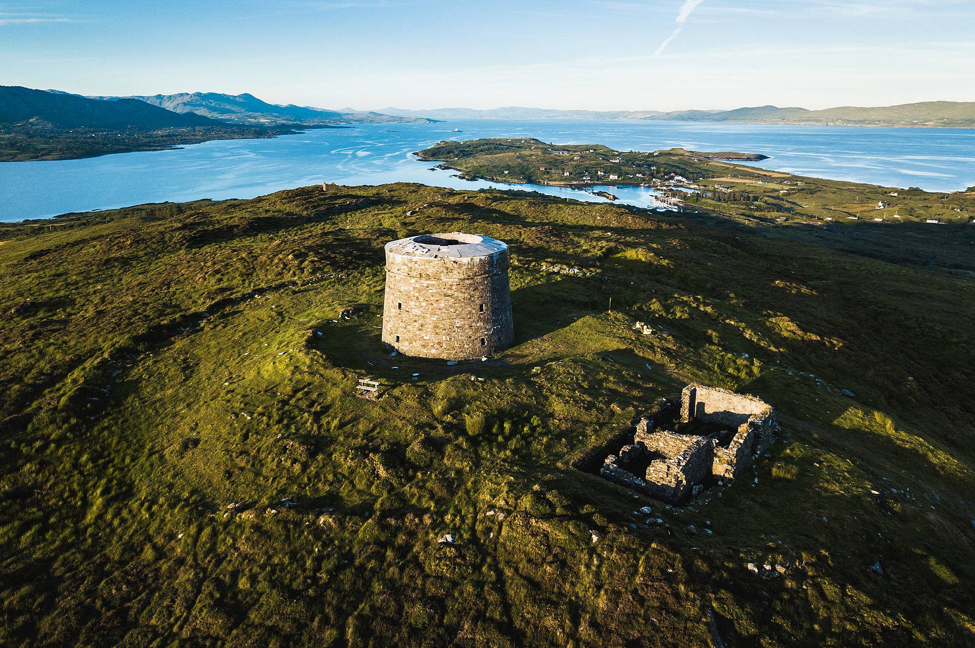
The route offers spectacular views of the historic Berehaven Harbour, and the entrance to Bantry Bay, taking in the Sheep’s Head Peninsula. It passes a Martello Tower and a standing stone which is said to mark the exact centre of the island.
FACILITIES:
Ferries leave from Castletownbere and the Pontoon with parking available at both slipways. Tea and coffee are available at The Bere Island Hotel, and Bakehouse, Rerrin. Public toilets are located on the west end pier.
LENGTH:
5km
FURTHER INFORMATION:
Bere Island parkrun: www.parkrun.ie/bereisland
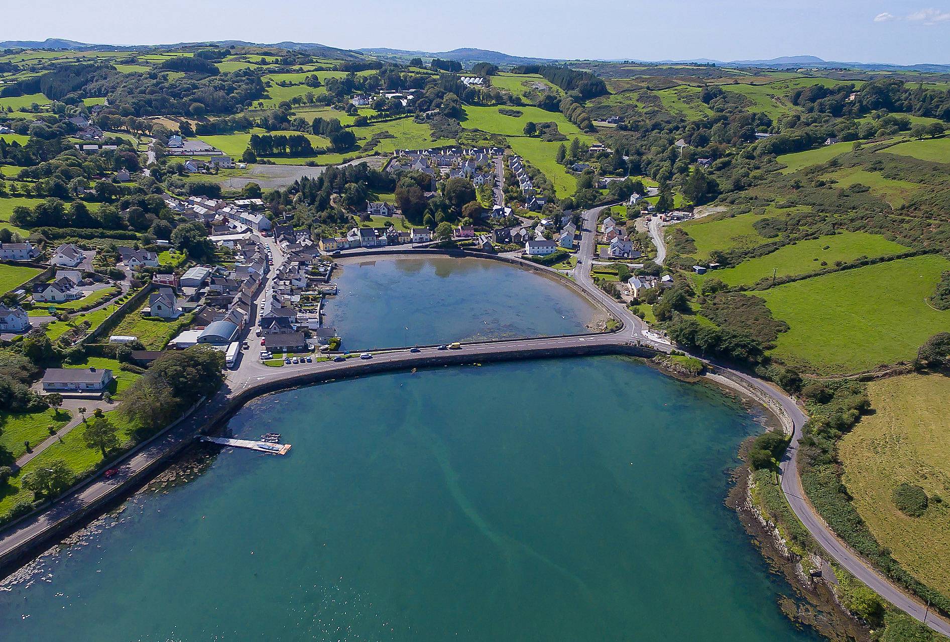
Béicín Walk, Bantry

The walk heads towards the sea, to a small bay known as Cove, it heads up past Reenrour, follow the way-markers to Marino Road, turn right after the medical centre, head under the piers of the old railway bridge, go left in front of a row of terraced cottages, emerging behind the fire station, turn left and left again to return to the square.
START/FINISH POINT:
Tourist Office, The Square, Bantry
(Eircode: P75 EY11/GPS 51°40’48.8”N 9°27’07.6”W)
DESCRIPTION:
The shore section of this walk offers views of Bantry Bay’s inner harbour with large numbers of black-headed gulls and mute swans. It follows part of the route of the old West Cork railway, in operation from 1881 to 1961.
FACILITIES:
Parking is available around Bantry Square and there is a wide choice of cafés and restaurants in the town. Public toilets are available opposite the Garda Station in the Square.
LENGTH:
2.5km
FURTHER INFORMATION:
www.bantry.ie • Bantry Athletic Club: www. bantryac.com
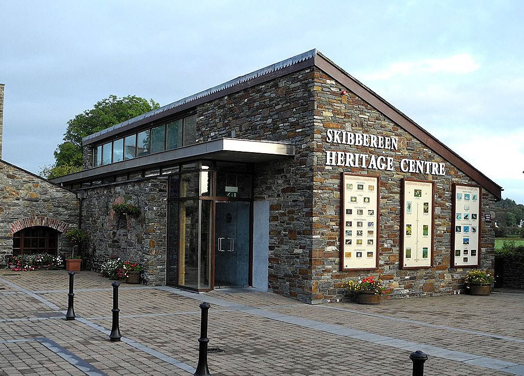
Rock Loop Walk, Skibbereen
ROUTE
The route starts at Skibbereen Heritage Centre on Upper Bridge Street, leads towards Bridge St, but taking a right turn through the atmospheric old railway cutting and across Mardyke Road onto the Baltimore Road where it loops back towards Market Street, heading up the Gortnaclohy Road and turning left onto Chapel Lane. It continues over Windmill Rock – temporarily closed for redevelopment but a slight detour takes you down to the Square – before heading up North Street, across the the Relief Road and back to the Heritage Centre via Ilen Street.
START/FINISH POINT
Skibbereen Heritage Centre. (Eircode: P81 WK06/GPS: 51.5509° N, 9.2719° W)
DESCRIPTION
This route takes in the historic West Cork town of Skibbereen which was one of the worst affected areas in Ireland during the Great Famine. The walk passes two old burial grounds and the Famine memorial and offers views over the town. Take time to take in the exhibitions at the Heritage Centre
FACILITIES
Parking is available in Skibbereen town centre, and there is a wide choice of cafes and eateries in the town for well-deserved refreshments afterwards.
LENGTH
4.5km
FOR FURTHER INFORMATION
www.skibbereen.ie • www.skibbereenwalkinggroup.com
Pier Walk, Rosscarbery

ROUTE
This level, easy walk starts at the Celtic Ross Hotel, and continues down the western side of the estuary to the pier, and then returns to the hotel.
START/FINISH POINT
Celtic Ross Hotel, Rosscarbery (Eircode: P85 WF86)
DESCRIPTION
The village of Rosscarbery is one of the most picturesque in West Cork and has a rich history as an ecclesiastical centre, dating back to medieval times. This meandering walk around the estuary is suitable for all ages and is a treasure trove for birdwatchers with a huge variety of species to see in the estuary including herons, oystercatchers, kestrel and peregrine falcons.
FACILITIES
Parking is available at the Celtic Ross Hotel along with a choice of eating options at the hotel including the popular bar and bistro, and an artisanal food truck located outside.
LENGTH
3.5km
FOR FURTHER INFORMATION
www.rosscarbery.ie • www.celticrosshotel.com
Timoleague to Courtmacsherry
ROUTE
This flat route along the old railway line is perfect for both runners and walkers The route is way-marked and follows the R601 road. Whilst it mainly overlooks the estuary, some parts of the route are wooded.
START/FINISH POINT
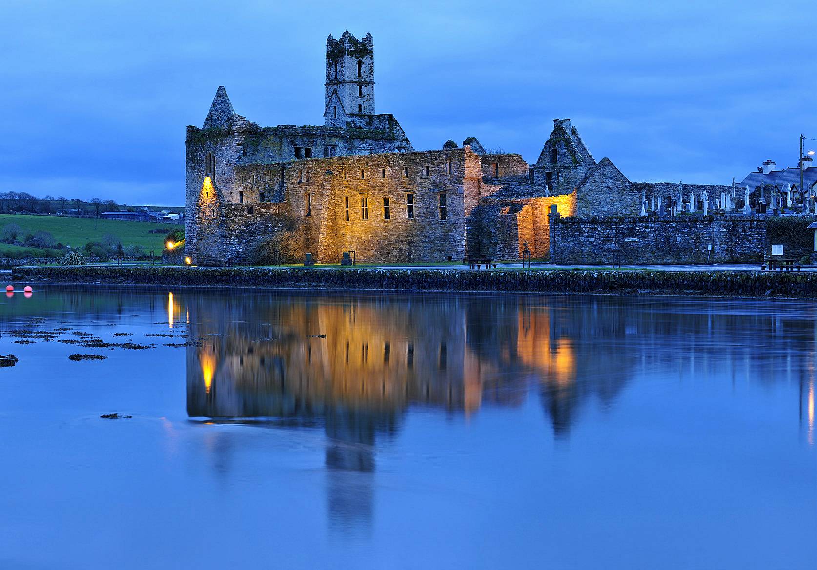
Timoleague Friary. (GPS: 51.6430° N, 8.7633° W)
DESCRIPTION
The route follows the line of the old Timoleague and Courtmacsherry railway which was Ireland’s last roadside railway when it ceased operation in 1947. The walk is a favourite for wildlife watchers, the estuary it follows is an important over wintering habitat for many birds. Timoleague Friary, where the route starts was founded in 1240 and is the largest medieval religious ruin in West Cork.
FACILITIES
The village of Timoleague is home to a number of restaurants, bars and cafes. Parking is available in the village.
LENGTH
8.8km
FOR FURTHER INFORMATION
www.cork-guide.ie • www.courtmacsherry.ie
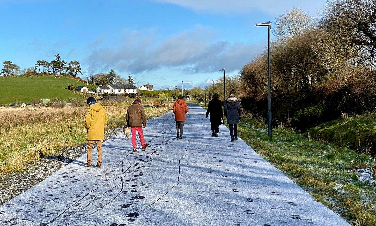
Joe Walsh Greenway, Clonakilty
ROUTE
Named in honour of former agriculture minister Joe Walsh who was from the area, this greenway leads from the west end of Clonakilty town, up a gentle incline and along the N71 passing the Sacred Heart Convent and Gullane Lake out by the technology park.
START/FINISH POINT
The route can be walked from either end.
DESCRIPTION
This easy 2km route is the perfect length for families with young children, and those with limited mobility. It is a flat, fully surfaced path and safe from the road with plenty of spots to sit for a rest.
FACILITIES
There is ample parking in Clonakilty and a wide selection of cafes, restaurants and bars for refreshments after your walk.
LENGTH
2km
FOR FURTHER INFORMATION
www.clonakilty.ie • www.parkrunireland.ie/clonakilty
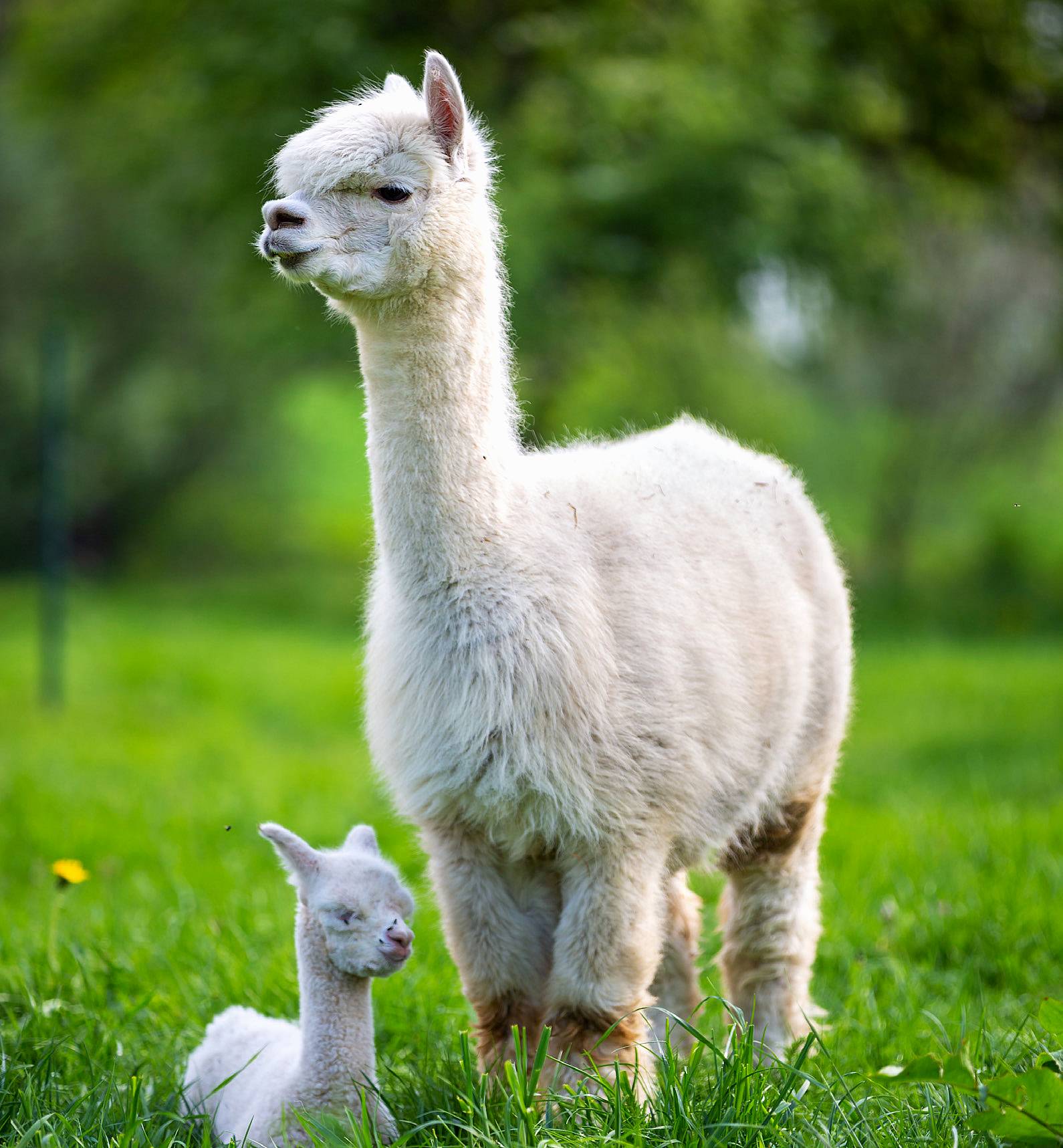
Alpaca Walk, Castledonovan
ROUTE
The route follows a winding trail past fields, streams and woodland.
START/FINISH POINT
Waterfall Alpaca Farm is located in Castledonovan which is a 7km drive from Drimoleague Village. (Eircode: P47 TD70)
DESCRIPTION
Alpacas are curious animals and love having company on their walks. You’ll have the opportunity to guide the alpaca along this loop walk on a trail which runs pasts fields with views across the countryside and also passes streams and a stunning waterfall en-route. There will also be an opportunity to meet some of the other animals on the farm including sheep, donkeys, hens, ducks and giant rabbits. Please note visits to the farm are by appointment only.
FACILITIES
There are plenty of picnic spots along the way, and parking and toilets are available on site.
LENGTH
2km
FOR FURTHER INFORMATION
www.westcorkalpacas.com • www.livingthesheepsheadway.com
Clare O’Leary Walkway, Bandon

ROUTE
This route in Bandon follows the path of the old Cork to Bandon railway and runs parallel to the N71.
START/FINISH POINT
The route is accessed via a public car park located on the right, roughly 4km from Bandon on the main road to Innishannon. GPS: 51.7687° N, 8.6898° W
DESCRIPTION
The route in Bandon, the largest town in West Cork, is named in honour of Bandon born mountaineer Clare O’Leary, who is the first Irish woman to reach the summit of Mount Everest. This flat, fully surfaced walkway overlooks the River Bandon and is fully accessible for wheelchairs and buggies.
FACILITIES
There is a public carpark at the start of the walk and a wide choice of cafes and restaurants both in Innishannon and Bandon. Public toilets are available in Bandon.
LENGTH
3km
FOR FURTHER INFORMATION
www.purecork.ie/bandon • www.bandonac.org
Scilly Walk, Kinsale

ROUTE
Starting in the town, walk/run down the lower road, as you turn the corner you’ll come to scenic Kinsale Harbour. The route continues along the water’s edge, leading to a steep hill, which well worth the climb as it gives a stunning view of the town from the top. At the top of the hill, take a left which takes you back up High Road and back towards the town.
START/FINISH POINT
Kinsale town, look for the Scilly Walk signs. (GPS: 51.7024° N, 8.5044° W)
DESCRIPTION
This route takes in the environs of Kinsale, overlooking the harbour, and historic forts from the Battle of Kinsale, James Fort and Charles Fort. On the final section of the walk, instead, of turning left up High Road, a right turn will take you towards Charles Fort.
FACILITIES
Public car parking is available in Kinsale, and in a town famed for its cuisine there are plenty of refreshment options!
LENGTH
6km
FOR FURTHER INFORMATION
www.kinsale.ie • www.riverstickkinsaleac.ie
Union Hall to Squince
ROUTE
Follow the dark blue arrows through the village of Union Hall, taking a left at the church, then a right at the junction to bring you to the old schoolhouse. At the next fork take the left turn passing Lough Cluhir on your right, the road continues straight ahead to Myross Causeway. A left turn leads to the bird sanctuary and onto Squince. At the end of the beach the route leads uphill, around a few bends leading to a junction, take a left here heading to the old schoolhouse, turn right at the crossroads and follow the road back to the village.
START/FINISH POINT
The walk starts and finishes at Causeway, Union Hall – next to the Rowing Club.
GPS: 51.559230 N, 9.140795 W
DESCRIPTION
This walk on public roads passes takes in Myross Causeway and Squince Beach. Myross forms an island due to the stretch of water which runs between Blind Harbour in the west and Squince Harbour in the east, with stone causeways giving access at either end.
FACILITIES
Parking is available in Union Hall with a variety of restaurants, bars and coffee shops.
LENGTH
10km
FOR FURTHER INFORMATION: